…. for no activity here for along time. I spend more time on Facebook and on my website – www.watsonlv.net .
I promise to come back here soon.
The summer of ’20.
… and what a mixed bag it’s been so far.
Dominated by the Covid virus, my half year has been marked up by breaking my ankle (on 29 December) and then suffering another bout of depression coincident with the pandemic.
Now the easing of Lockdown has begun, I feel a lot brighter and looking forward to getting back to the new normal.
Highlight of the year? Receiving our new puppy on the 20 April see https://www.watsonlv.net/cats.shtml
Oh well, onward and … onward.
Sunday Sermon
https://www.facebook.com/leslie.watson.311493
Loads of neat stuff here – he said modestly.
England ungreened
Slowly, slowly and then fastly fastly the countryside surrounding our towns is being eaten up by ‘the concrete monster of progress’. I am mapping the recent and future development around my town, based on Ordnance Survey 1:25,000 mapping, local planning documents, and a variety of sources.
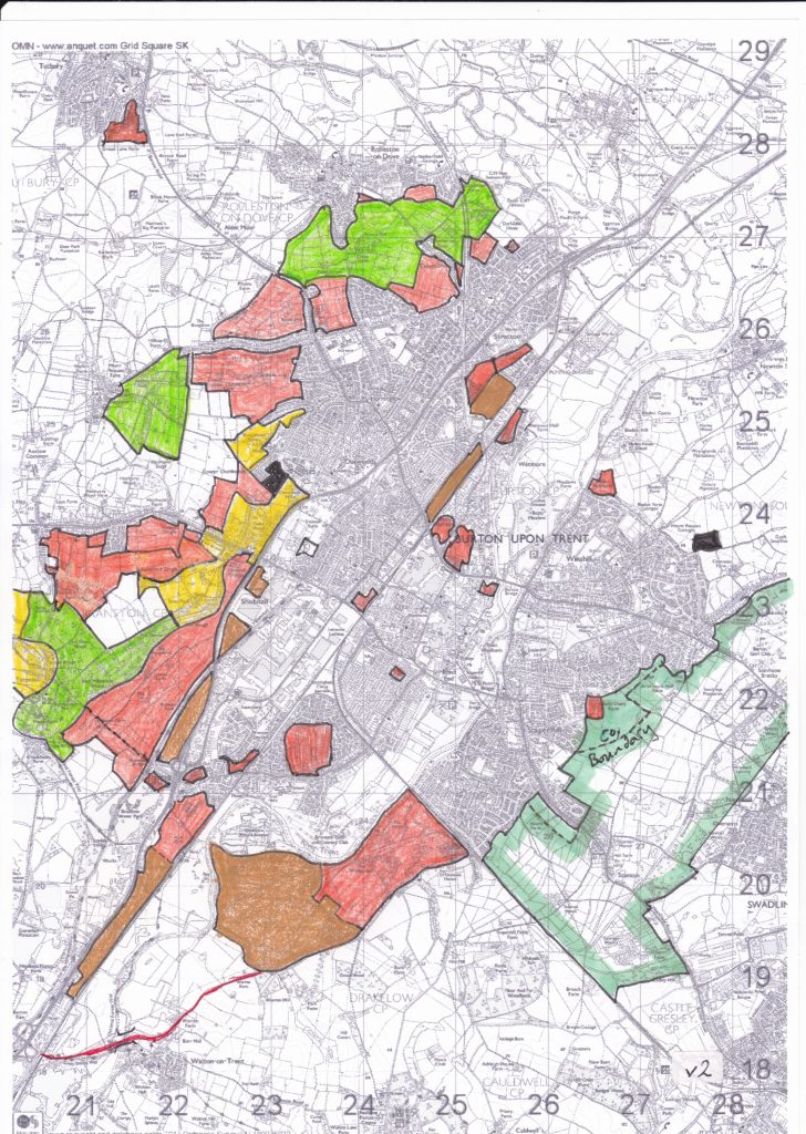
It’s eight months since I began posting about the ‘ungreening of England’ (http://wordpress.watsonlv.net/index.php/2018/07/25/the-ungreening-of-england-burton-area/) adding more information to the map of the Burton-on-Trent area, thus making substantive revisions each time. This updated map includes a proposed development (aka land grab) to the west of the town called Postern Park which will include up to 750 houses, a secondary school, playing fields, ‘retail/community’ and formal open spaces.
“The site currently has agricultural use, principally pasture, but also an Adventure Farm, which has a hard surface car park, play area and animal enclosures, accessed north of Postern Farmhouse, off Postern Road. The existing Grade 2 Listed farmhouse is only visible from a narrow stretch of Postern Road to the south, and is wrapped by existing farm buildings.” In no way can this pleasant area of grassland along the Needwood Forest eastern boundary be considered a ‘brownfield’ site.
This land grab is in addition to 2,500 homes to be built at Branston Locks, as well as 300 homes to the south of Forest Road and up to 250 homes at Lower Outwoods Road.
The total number of new homes on the map is now approximately 10,600.
Key:
Red – mostly housing
Brown – mainly commercial
Black – failed housing application
Green enclosed area – Green Belt across the South Derbyshire / Staffordshire border
Solid green – the so-called Rolleston / Stretton ‘Green Gap’. Not Green Belt
Yellow – area of high quality landscape
Red line – Walton river crossing and road improvements. Construction due to start ‘soon’
Ind Coope Ltd Operations at Tatenhill Airfield, Staffordshire
Following the post-war release of Tatenhill aerodrome by the RAF to the Duchy of Lancaster’s tenants in c1953, it was disused for a few years, The Burton-Newborough road (B5234), which traverses the site, had been closed ‘for the duration’ and was reopened in May 1954.
In 1959 the Burton upon Trent based Ind Coope brewery, who had a fleet of executive aircraft based at Burnaston airfield, acquired the lease to Tatenhill and transferred its operations there. On the north-east side of the perimeter track the company erected a remodelled, re-used Bellman hanger with a new control tower and office suite attached. At first only the eastern two-thirds of runway 08/26 was used. The other runways deteriorated rapidly and were used only occasionally. Runway 16/34 became disused very quickly while 04/22 was soon suitable for light aircraft only. Runway 08/26 was later extended to its present length of 1200m (1312 yds). A radar facility was erected at the convergence of 08/26 and 16/34 to deal with the dense winter fogs encountered over the Needwood Forest.
At commencement of operations Ind Coope transferred Captain David Lancaster (ex-RAF Fighter pilot) from Manchester to Tatenhill to become Chief Pilot. Captain Wally Evans DFC was appointed as his no. 2, with Chief Engineer Terry McCarthy completing the team. In 1961 Dave Moon replaced Terry McCarthy and he remained as Chief Engineer throughout, taking retirement in 1985. The team were joined by Captain Laurie Walford (ex-RAF) in 1968, who went on to became Chief Pilot upon David Lancaster’s retirement. At its height the company had five pilots on site. At various times the brewery owned several executive aircraft based at Tatenhill including:
G-APCZ de Havilland 104 Dove
G-ARDE de Havilland 104 Dove 6
G-ASNO Beech B55 Baron
Beech B 58 Baron
S-ASru Beech 865-A80 Queen Air
G-ASXV Beech 865-A80 Queen Air
G-BCUZ Beech King Air 200
By the end of its operation the company had a Beechcraft King Air 90 and a Beechcraft King Air 200.
A highlight for all the staff at Tatenhill was a visit by HM the Queen in 1982 who, after visiting the Duchy of Lancaster estates in the Needwood Forest, flew out from the airfield in a Royal Flight aircraft. Laurie Walford, Dave Moon and other members of the team were presented to her before she departed.
The wartime watch tower became derelict during this period and was considered structurally unsafe. Concern was expressed that children using it as a playground might be injured and it was demolished in 1982/3.
The years 1984-5 saw large cutbacks at Allied Breweries which resulted in the closure of operations at Tatenhill in July 1985. The workforce, including Laurie Walford and Dave Moon, were made redundant and the aircraft sold. Thus ended a period of over 25 years private flying from the airfield.
Based mainly on information from Laurie Walford, Dave Moon and Fay Insley employed at that time by Ind Coope. AMWD plan nos. 13726/41 and 15683/41.
See also: www.watsonlv.net/tatenhill.shtml
From the archive
Resignation from the British Labour Party.
Please accept my resignation from the Labour Party on receipt of this letter. I have thought long and hard about this decision. Here is a sample of my reasons for leaving:
- I joined the Party a couple of months before the General Election that brought Mrs Thatcher into power. I was ‘inducted’ by ‘Red Ted Knight in Brixton and was active in London, in Burton and elsewhere during the 1980s and 1990s. I believed that a Socialist society was the only alternative to rampant Toryism of the time. Both of my parents are lifelong Labour supporters. It was in the blood.
- My decision to leave has evolved since the Iraq war and the financial crisis of 2007–08. I consider the crisis has exposed the contradictions and weaknesses of the neo-liberal economic experiment: attempting to make global corporations and capitalism profitable by making the rich richer at the expense of working people. This began in the early 1970s, it influenced the 1974–79 Labour Government; was extensively implemented by the Tories 1979–1997; little modified by Labour 1997–2010 and has been accelerated by the current Tory government. This near decade of economic depression has exposed this agenda for all to see and created the conditions for truly radical change.
- Any challenge to the neo-liberal agenda has now been compromised by the One Nation Labour approach based upon ‘responsible capitalism’ epitomised by the Union Jack emblem that would fit the Tories just as well. Austerity has now been accepted by the Party and is being implemented by Labour councils up and down the UK under the ‘dented shield’ rhetoric.
- Iraq, Afghanistan, Palestine, elsewhere. It’s hard to know where to start. I didn’t join the party shortly after the ‘fall of Saigon’ expecting to find the government and it main so-called opposition party 35 years later pursuing Armed conflict around the world – more than ever in history. Along with our ‘allies’, Britain has invaded and desolated so many countries that I cannot, with honesty, support a party that talks peace but promotes wars. I believe Labour’s foreign policy is merely an ersatz version of the corrupting Tory (neo-con) ambition abroad.
- I feel the austerity ‘Lite’ promoted by the Labour leadership is hypocritical. Fighting the Tories by Tory defined rules is simply unacceptable.
For the above, and other, reasons I am no longer able to vote Labour or be a labour supporter. Will you please remove me from the membership list and cancel my direct debit.
5 August 2015
Unsurprisingly, I didn’t receive a reply. I then went off to sign up with the Green Party. More my kind of guys/girls.
Don’t get me wrong …
… I’m not obsessed with the loss of countryside in my home area. My past four posts illustrate the knowledge added since since version 1. Here’s the first image of August 2015:-
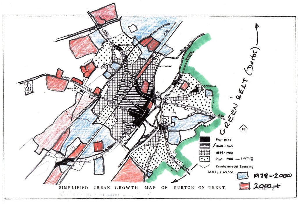
The base map is from The Development of Industry in Burton upon Trent by CC Owen (1978). It remains unsurpassed, available in a charity bookshop near you.
The map shows the overall development in Burton up to the date of the book’s publication during the housing boom of the mid 70s. Comparison with the current Ordnance Survey Explorer Map sheet 245 also allows an appreciation of growth from then to now.
The ungreening of England: Burton upon Trent
The ungreening of England: Burton area. Christmas edition.
Slowly, slowly and then fastly fastly the countryside surrounding our towns is being eaten up by ‘the concrete monster of progress’. Here’s a local example; based on Ordnance Survey 1:25,000 mapping and a variety of sources, I give you an updated sketch map showing recent and future ‘development’ in the Burton area.
Key:-
Red – mostly housing (about 12,200 units)
Brown – mainly commercial
Black – failed housing application
Green enclosed area – Green Belt across the South Derbyshire / Staffordshire border
Solid green – the so-called Rolleston / Stretton ‘Green Gap’. Not Green Belt
Yellow – area of high quality landscape
Red line – Walton river crossing and road improvement. Construction due to start ‘soon’
The ungreening of England – Burton upon Trent – update
The ungreening of England: Burton area.
Slowly, slowly and then fastly fastly the countryside surrounding our towns is being eaten up by ‘the concrete monster of progress’. Here’s a local example; based on Ordnance Survey 1:25,000 mapping and a variety of sources, I give you a sketch map showing recent and future ‘development’ in the Burton area.
Updated with orange!
Recent & future development in Burton area v10
Key:-
Yellow – mostly housing (about 12,200 units)
Black – failed housing applications
Solid green – the so-called Rolleston / Stretton ‘Green Gap’ (not Green Belt)
Green enclosed area – South Derbyshire Green Belt against the Staffordshire border
Vertical green stripes – Burton Green belt(!)
Orange / orange strips – area of high quality landscape
Oblique green stripes – amenities areas
Brown – mainly commercial
Enclosed area north of town centre – proposed Derby Road ‘gateway’ improvement scheme (housing, commercial and amenities)
Crimson – gravel quarrying
Green line – possible route of A514 connecting road (A38 to A50 nr Derby).
The ungreening of England: Burton area – update
Recent & future development in Burton area v9
Click on the title above for an updated map.
Key:-
Yellow – mostly housing (about 12,200 units)
Black – failed housing applications
Solid green – the so-called Rolleston / Stretton ‘Green Gap’ (not Green Belt)
Green enclosed area – South Derbyshire Green Belt against the Staffordshire border
Vertical green stripes – Burton Green belt (!)
Oblique green stripes – amenities areas
Brown – mainly commercial
Enclosed area north of town centre – proposed Derby Road ‘gateway’ improvement scheme (housing, commercial and amenities)
Crimson – gravel quarrying
Green line – possible route of A514 connecting road (A38 to A50 nr Derby).